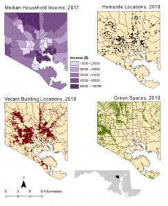
I was pleased to read so much about the modifiable areal unit problem (MAUP) in Marceau’s discussion of scale, as last semester this was a constant thorn in my side. In one final project, I had major issues with the aggregate problem he describes. I was trying to correlate homicide locations in Baltimore to different spatial characteristics, namely socioeconomic status, green space, and vacant buildings. I had the location of every homicide in Baltimore in 2017, vacant building in Baltimore, and a layer file for every park and green space in the city. However, for socioeconomic status I only had the average income for large swaths of the city called “community statistical areas;” these were not nearly as granular as the homicide locations, vacant building sites, and green spaces. There were no better spatial data for socioeconomic status that I could find, so these were the data I used. My analysis revealed that, using these data, both vacant building locations and green spaces are significantly correlated to homicide locations but income is not. However, this does not prove that neighborhood income isn’t correlated to homicide incidence as the income data I used are low resolution compared to the other data (see the maps below for comparison). I happened to conduct multiple regression models for this project, the exact type that Marceau cites as being vulnerable to the MAUP: “the authors [of one study on the MAUP] demonstrated that modification of the areal units from which data are collected create a severe problem for parameter estimation in multiple regression models” (1999). Therefore, I was right to be cautious about the conclusions drawn from my own Baltimore analysis. In addition, I will have to keep the MAUP in mind for my GEOG 506 project as my theme is geodemographics and any demographic data I use will certainly be aggregated to some scalar unit.
